
Life's just a bowl of cherries!
Sunday-Tuesday June 3rd-5th, 2007Capitol Reef National Park

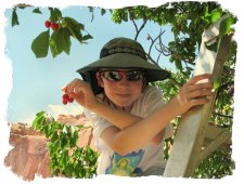 Life's just a bowl of cherries.....when you're in Capitol Reef National Park and the U-Pick fruit sign goes up! We were viewing petroglyphs across the road from Holt Orchard when the ranger announced that we could help ourselves to ripe cherries. The Park provides ladders and you're welcome to pick the fruit and eat as much as you like on the spot or you can bag it, weigh it, pay a nominal fee per pound and enjoy it later! How wonderful is that? There's more and I'll tell you about that in a minute.
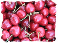 ...Make gardens, orchards, and vineyards, and render the earth so pleasant that when you look upon your labors, you may do so with pleasure, and that angels may delight to come and visit your beautiful locations
- Brigham Young, to Mormon Settlers in southern Utah.
The historic district in Capitol Reef National Park (called Fruita) is chock full of various orchards that lie within a mile or two of the Visitor Center. These trees - apple, pear, peach, cherry, apricot, mulberry, even Potowatomee Plum - are the most obvious reminder of the pioneer community that once prospered in the narrow valley of the Fremont River. Today, the heirloom trees that were planted by Mormon settlers over a hundred years ago are maintained by the Park Service. A rare oasis in the desert, it is truly a Red Rock Eden.
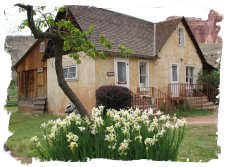 We must have been needing this restful spot. Under the shade trees and rimmed in by colorful cliffs, we spent lots of leisurely hours playing board games and simply enjoying the pleasure of the setting. Here's the best part - the historic Gifford Farm is adjacent to the campground and every morning they get a delivery of fresh fruit pies from nearby Torrey. The pies are still warm when the gift shop/museum opens at 9 a.m. If you prefer your pie ala mode, no problem, they also sell homemade ice cream! Wow ~ what a treat ~ and we came here just expecting more Geology 101.
I'll let the Professor take over from here!

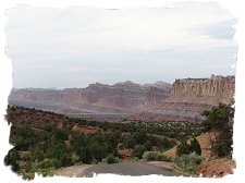
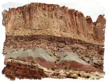
If you are a geologist who loves fruit pies, this would be heaven on earth. Capitol Reef is centered around the Waterpocket Fold, a hundred mile long crease in the earth's crust. Honestly, to the uninitiated, the fold doesn't look all that different from any of the numerous long and colorful cliff lines that dot the landscape in southern Utah and northern Arizona. What is unique from a geology standpoint is that layers of earth that are usually hundreds or thousands of feet deep were thrust upwards, creating the huge bend or fold in the earth called Waterpocket Fold. The park got it's name from a distinctive white sandstone dome that looks like the Capitol Dome.
 I've never really grasped geology, I think because usually it is presented from only a local context. For example, you always see diagrams of layers of rock...this is the Wingate formation, that is the Navajo, under that the Chinle....and it never made much sense to me. How did they get there? Why and how are they dated?
A poster in the Capitol Reef Bookstore finally made it all clear. It showed all the layers of rock in the Colorado Plateau (a large area roughly centered on the Four Corners area). The interesting thing was it started in western Utah (at Cedar Breaks), then went thru Zion, Bryce Canyon, Capitol Reef, then Arches, with the Grand Canyon also displayed (The Bryce Canyon Visitor Center also has a very good diagram showing this). I could see where the layers stretched across a wide area.
For example the bottom layer of Zion (Kaibab formation) was the top layer of the Grand Canyon (a step down in elevation, as for the most part, the layers are mostly flat.). This area of the country is called the Grand Staircase, largely because of a series of long cliffs where the elevation drops several thousand feet, from nearly 10,000 ft. in Western Utah, to around 4500 ft. in eastern Utah. At each line of cliffs (The White, Grey, Pink & Vermillion Cliffs), the layers comes to an end, and lower (and older) layers are exposed.
This made sense to me, coupled with the explanation how each layer (formations, in the technical term) were created due to the environmental conditions at that time. Some were compressed sand dunes. Some were formed by deposits from shallow lakes. Some were largely organic material from a long ago sea covering a large part of the modern western US.
 This also helped answer another question - why do you only tend to find dinosaur fossils in certain areas? Because you need to find the layer of rock that got laid down in the era when dinosaurs lived. It also needs to be somewhere where this particular formation (Morrison) is exposed to the surface, either by erosion of higher (and younger) layers, or somewhere like Capitol Reef where the earth has been creased or folded, raising the formation up.
Ok, enough geology for now, I'll just leave it to say I now feel like I've got a basic clue, where before I was completely clueless. Capitol Reef is a good location for those who aren't clueless - we bumped into a large group of geology students from UC Santa Barbara, who were spending several days camping in the backcountry of the park, studying the geology. This must be fairly common, as Denise met another group from Texas A&M doing basically the same thing around Arches NP.
Back to something more interesting - the fruit pies!! The organization that helps out the park (similar to Friends of the Smokies, which we belong to) runs a shop in the historic Gifford Homestead, located next to the campground. Vance and I were waiting when they opened, and loaded up on a couple of cherry and mixed berry pies. Yum, Yum, Yummy! The historic aspect of the old orchards, the pies, and getting to pick our own cherries was an unexpected surprise out here in the middle of the desert.
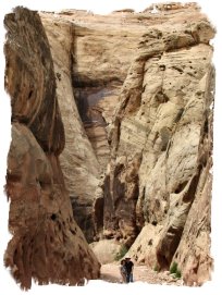 Trying to get in at least one good hike at each national park, the three of us set out on the 'Grand Wash' hike. Grand Wash is a small canyon (small, in the fact the walls were 300-400 feet high, vs the couple of thousand we will bump into later at Zion and other places). A couple of miles in the canyon narrows to only 14 feet wide. It was a pretty, quiet hike, at least until the gunfight....
....an explanation is in order. Back when we were at Guadalupe Mtns NP, as a joke I had started singing the old Marty Robbins tune, 'Back in the West Texas town of El Paso....', knowing we'd pass by El Paso on the way to our next stop. Here at the Capitol Reef Book Store, I found a Marty Robbins "Gunfighter Ballads" CD, and played the song for Vance.
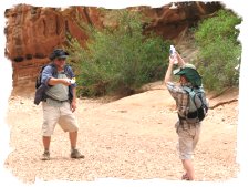 Denise and I both loved this album as children, and it must be genetic, because Vance insisted that we buy it. Big Mistake. We have listened to nothing else since then - he loves it, particularly the first song 'Big Iron', talking about a gunfight between an Arizona Ranger and the Outlaw Texas Red. When not listening to the CD or singing the songs, he now wants to mock gunfight all the time. So we had the 'Shootout at Grand Wash', using water bottles. It was pretty funny, all in all. You can guess who wound up laying face down in the dirt playing dead ;-(
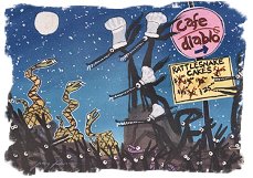 Our 13th wedding anniversary coincided with our visit here, and lucky for us, the 'Cafe Diablo ' is located in nearby Torrey, Utah. The Cafe is the caterer for the fruit pies, and was a ridiculously good dining experience in what really is not much more than a little crossroads town outside the park.
Hoping to put an end to Denise's snake phobias, I decided to show the rattlesnakes who was boss, and ordered rattlesnake patties for an appetizer. (Denise wanted to know if we could get it without the head!) Incidentally, our waitress informed us the rattlesnake meat came from West Texas - right about where we saw our last one! The Cafe was a nice find, and we enjoyed being able to have a nice dining experience, rather than another round of Chili Macaroni in the camper ;-)
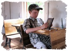 The park also offered tours of the historic one room Fruita Schoolhouse, and ranger programs on the various petroglyphs along the Fremont River Gorge. We enjoyed talking with the ranger at the schoolhouse at length about her experience as a seasonal ranger. Vance really seemed to enjoy looking through the old school books, spending quite a bit of time looking at the 5th grade reader.
All in all, the park was a nice surprise and a real gem located between the better known showboat parks of Arches and Bryce Canyon. A lot of people use this only as a quick camping pit stop between these two parks - the campground would fill up early afternoon, and empty out the next morning. We enjoyed just hanging out for a few days, learning a bit of history about the early Mormon settlers, the Fremont People (early Native Americans in this region), and of course, some geology. On top of that, warm cherry pie with ice cream!

Vance: Capitol Reef NP is a very popular park. Capitol Reef has many interesting things. One attraction is Capitol Dome. Bighorn Sheep live in the park (we didn't see any). We even camped inside the park.
For Mom and Dad’s anniversary, we went to a restaurant named Café Diablo. We had a appetizer called rattlesnake cakes. We also hiked into the Capitol Reef Narrows.
ANOTHER NAME FOR THE NARROWS IS THE GRAND WASH!
| Previous - Happy Trails | | Home | Index | | Hoodoos on Horseback - Next |


<< Home