Thar's Cold in dem thar hills
Thursday, May 24, 2007The San Juan Skyway
Durango, Silverton, Ouray, Ridgeway and Telluride, Colorado
In May of 1990, I spent two weeks driving cross country to California after accepting a year long temporary assignment from IBM in San Jose. Enroute, I spent a memorable day driving half of the amazing San Juan Skyway scenic route. The views from that drive have always stayed with me, and finding ourselves in the area, the loop drive was a must-do.
 The San Juan Skyway Scenic Byway is a circular route that goes up, over and sometimes between the rugged San Juan and Uncompahgre Mountain ranges in southwestern Colorado. Rising up 14,000+ feet from the desert floor they form an imposing barrier across that portion of the state. The San Juan Skyway is a series of spectacular highways that connect the various towns and villages in the San Juan Mtns. The roads are largely direct descendants of early wagon trails, later followed by narrow gauge railroad lines, built to haul silver ore out of the vast deposits discovered in the largely inaccessible areas. Most of the surviving towns were silver mining towns that have survived largely due to tourism.
Our drive started in Cortez, CO (near Mesa Verde), where we were camped. After a pleasant drive through rolling hills, bordered by the huge uplift of Mesa Verde on the right, and the San Juan Mtns on the left, we reached the thriving down of Durango, Colorado. The drive around the Skyway is long (236 miles), so be warned – this post is rather long also!
Durango
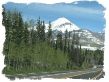
 I spent one evening in Durango on the trip mentioned above. The view from the hotel window was of these little steam engines puffing around the railyard of the Durango and Silverton Narrow Gauge Railroad. I knew nothing of the railroad up until then, and was hugely disappointed that there wasn’t time to take the train ride. However, good things come to those who wait (even if it is 17 years), and Denise, Vance and I had a great time the next day riding the train.
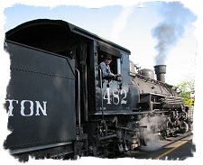
 The heart of Durango is the historic district, a collection of western and Victorian style buildings. Many of the businesses in this district are aimed at serving the train passengers. We stopped at a Starbucks a few doors down from the train station (Denise really, really, really wanting a good cup of coffee instead of the normal camper brew!).
We couldn’t help but notice the contrast in environments between the buildings and businesses surrounding the train in Durango compared to those in our hometown of Bryson City, NC (where it’s sister railroad, the Great Smoky Mountains Railroad is located). Instead of a Dollar General across the street, there are good coffee shops, bakeries and stores sporting the rich smell of leather. Both Durango and Bryson City owe a great deal of their current prosperity to the railroads, however Durango seems much more attuned to and comfortable with the railroad in its midst.
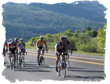 One of the other things I noticed on my first trip to Durango was the large number of bicyclists in town. I left Durango convinced it was the biking capital of the world! This time back I found out why – over the upcoming Memorial Day weekend was the ‘Iron Horse’ ride. Bicyclists from all over the world come to ‘race’ the train from Durango to Silverton. The difference is the old steam engines follow the Animas River, where the cyclists have to climb over not one but two mtn passes exceeding 10,000 feet! I must have just missed the race my during my first visit, so undoubtedly the town’s cycling population would have been dramatically increased, like it was on this visit. We didn’t see the race, but saw plenty of bikers out doing practice runs – some even leaving at the same time as our train ride on Friday, in order to make the training as real as possible!
We really like Durango. If we ever decided to look at the Colorado Rockies as a place to live, this would be a place we would consider.
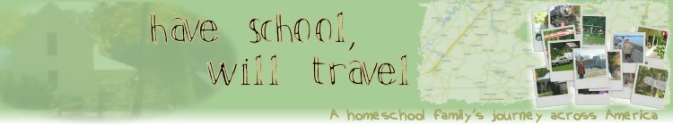
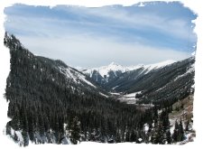
The Byway follows US 550 north from Durango. For several miles, the hills rise alongside the highway, the rocky cliffs a fiery red color. Eventually the road climbs out of the red rock into a more traditional mountain setting. (Durango is at 5600 feet, we top out over 10,600 feet on this part of the drive). The terrain and vegetation changes rapidly, with the quaking Aspens taking over. The San Juans are coated with a fresh layer of snow, courtesy of the same storm that turned our first two days at Mesa Verde into a winter wonderland.
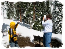 The San Juan Mountains are simply magnificent. The Skyway passes 10 peaks over 14,000 feet, with numerous others topping 13,000. Twice during the stretch between Durango and Silverton we crossed passes over 10,600 feet. Of course we had the inevitable snowball fight at the top, where the snow was several feet deep.
If you should, in your imagination, put together in one small group, perhaps 12 square miles, all the heights and depths, the rugged precipices and polished faces of rock, and all the sharp pinnacles and deeply indented crests, and 20 times the inaccessible summits that both of us have ever seen, you would not have a picture equal to this.
- W.H. Holmes, U.S. Geological Survey (September, 1876)
Silverton
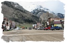 Coming down off the passes, we enter the old mining town of Silverton, the other end of the Durango and Silverton RR. Silverton sits at over 9000 feet in a valley surrounded by huge mountains. The town looks much today like it did originally, with a raw, western feel to it. Much of the effect comes from the fact that none of the roads in Silverton are paved – downtown is crisscrossed with wide, dirt streets.
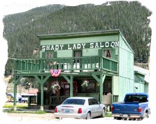 In its mining days, Silverton was divided into the respectable and well, not so respectable sides of towns. Blair Street was full of bars, women of low repute, and apparently was so notorious that both ends of the street were renamed ‘Empire Street’ by residents not wanting to be tainted by its reputation! Today, the train disembarks at Blair Street, which is still full of old saloons and other shops.
Although we didn’t take advantage of it, there are several silver mine tours available in the Silverton area. In addition to the train, the Kendall Mtn ski resort is nearby. As far as scenic locations for a town, it would be hard to top Silverton, except for maybe Ouray (coming up soon!)
The Million Dollar Highway
There is an ‘Oh My God’ highway in Colorado, but after driving the ‘Million Dollar Hwy’ from Silverton to Ouray, I’m not sure I want to find out what it’s like. The Million Dollar Hwy is so named because of:- The price per mile of the highway when first constructed in the late 1800’s
- The amount of gold and silver still in the mine tailings used to construct it
- The million dollar views you get around every corner (and there are lots of them)
- The amount of money a driver is willing to pay to get off the road alive!
 Nobody is really sure where the name came from, but it is appropriate. The road, which twists and turns so much I’m not sure how the builders kept it all straight in their heads, is justifiably famous for it’s outrageous views. Climbing to over 11,000 feet at one point, the road hangs on the side of mtn cliffs, s-curves upon itself time and time again, and is painfully narrow in places without the benefit of guardrails to at least give you the illusion of safety.
It’s quite a drive. Make sure someone else is driving, so you can enjoy the scenery, because the driver won’t get much time to look around! The roadbed is built along the original narrow gauge railroad bed, constructed in the 1880’s. There are times you really wish they'd used a few more sticks of dynamite when constructing the road. Most of the time there is little but a few small pebbles between the edge of the road and oblivion in a canyon far, far, below.
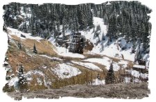 The Red Mountain area is dotted with the headframes of old silver mines and ghost towns. This area was extremely rich in silver ore, mined as late as 1978. The Idarado Mining company eventually acquired most of the mining sites in the Silverton, Red Mountain, Ouray and Telluride area (with mining tunnels connecting Red Mountain and Telluride, about a 70 mile drive by car, 5 by mine tunnel!). Today, the company is sponsoring remedial cleanup projects on large mine tailings in the area. The tailings are full of nasty chemical ores that pollute area creeks, killing any and all aquatic life in the creeks. The tailings are easy to spot on the mountain sides, indicating locations of former mines.
Ouray
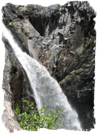 I spent maybe 5 mins in Ouray on my 1990 trip, but I’ve always remembered them. Just outside of Ouray on the Million Dollar Hwy is a spot where the road narrows down on a curve hanging high on a canyon wall. Off to the right is a long, thin waterfall. To the right is another large waterfall, starting under the highway bridge. Finally, there is a third torrent working it’s way down the canyon from the direction you just came.
I can’t even come close to describing how unbelievably beautiful this spot is. You will just have to see if for yourself.
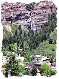 Ouray itself is what I really remember. Another old mining town, it’s distinctive feature is a high set of waterfalls immediately behind the town. It’s a striking view, and one that I remembered well, telling Denise we had to see this little mining town with the huge waterfall behind it.
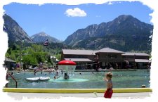
Ouray, the Little Switzerland of the Rockies, has been rediscovered in recent years, undergoing a revitalization with new restaurants and businesses. It too is a beautiful setting, rivaling anything I’ve seen anywhere. A main attraction is the Hot Springs Pool, a city run complex. Vance saw the pools and wanted to stop and swim, but given that we still had 150 miles to go on our loop, we had to skip it at the time.
Skipping ahead a few days – feeling the onset of ‘road weariness’ or ‘travel fatigue’ when we reached the Black Canyon of the Gunnison, we decided to take a break and surprise Vance. Driving back down to Ouray, we spent a delightful afternoon and evening at the hot springs. The pool complex is divided up into sections of different temperatures – a warm wading area for small children, slightly hotter play area with slides for kids, and the hot section for adults wanting the soak. The pools are fed off a series of natural hot springs located in nearby Box Canyon. It's a striking contrast to relax and soak in the 104 degree mineral water while looking up at the snow capped vista.
 It felt GREAT! Deciding to give in to the moment, both Denise and I opted for massages, offered in a poolside studio. The sun set shortly after our massages were complete, followed by a dramatic moon rise over the surrounding snow covered mountain peaks.
Aaaaaaaaaaaahhhhhhhhhhhh! This is the life………..
When we reluctantly dressed to leave, Denise got into a conversation with the lady running the front desk of the pool. She had lived in Ouray for 50 years, first coming to the town as a child. Her father was a miner who worked in the Red Mountain mines. Because of the connecting tunnel between Red Mtn and Telluride, they could live in either area and be close to his work. Because of the hot springs pool (which has been in Ouray for a long, long time), they chose Ouray (she joked that her life might have been a lot different had her parents invested in real estate in Telluride at the time!). She graduated high school in a class of 18. Ouray hasn’t changed all that much, the recent graduating class only had 22 in it.
Ridgeway
Jumping back in time to the day of our driving tour, Ridgeway was the next town. Immediately after leaving Ouray, the terrain changes dramatically, returning to the red rock we first saw around Durango. About 10 miles down the road lies Ridgeway. Vance wanted to play, so we stopped at a very nice park on the edge of the historic downtown for a couple of hours. Ridgeway also has a dramatic setting, with the San Juans on three sides of the town.
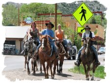 Again jumping ahead, a few days later we came through Ridgeway when moving the camper to the Black Canyon of the Gunnison. Again we stopped, this time to eat at the ‘True Grit’ Café. True Grit (starring John Wayne) and several other westerns were filmed in Ridgeway. Denise really likes Ridgeway.....so does Ralph Lauren and Dennis Hopper, who reputedly own ranches in the area.
While we were dining, several horsemen (and women) came riding up and tied their horses to the hitching post out front of the restaurant (yes, it was that kind of town). Again we spent several hours in the park, Vance enjoying a chance to get out and play with a large group of children. There we met a family who had a pet baby duck, which rapidly became quite the celebrity in the park.
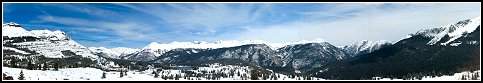
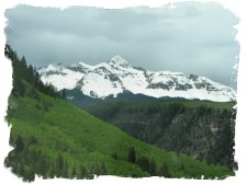 The ride between Ridgeway and Telluride is jaw droppingly beautiful – there is a wide panorama of the snow capped San Juans rising above a large expanse of green meadows. We loved this part of the drive both coming (on our loop trip) and going (moving the camper to the Black Canyon).
Telluride
Oprah has a home here. Need I say more?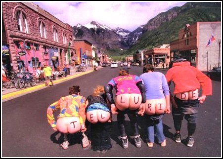
Sorry, we couldn't resist.
Anyway, back to Telluride. It is set in another one of these 'Oh my god' valleys. Part of the draw of the town is the scenic setting, with the nearby nearby ski resort, and part of it is the desire to be one of the rich and famous (land and house prices start in the multi-millions, even for small condos).
Telluride is beginning to suffer the problems the ultra-rich bring with them - no one else can afford to to live or visit there. Downtown, while vibrant, has stands of vacant buildings, and letters and editorials in the local paper decry the fact that it is too expensive for normal folks to run businesses, visit (hotel prices start at $1000 a night), or live.
But don't feel too sorry for them. Telluride just raised $50 million big ones from the locals in a campaign to buy some of the remaining valley floor property for a park.
The name 'Telluride' comes from either a derivation of Telluridium, a rare element never found there, or from 'To hell you ride', a description of the difficulties reaching the remote mining town in the early days.
Historical note - the San Miguel Valley Bank was robbed by Butch Cassidy - his first robbery. Telluride was also the location of the worlds first commercial Alternating Current (AC) power plant, built by George Westinghouse and Nikola Tesla, to supply power to one of the nearby mines. The success of this project lead to Westinghouse building his famous Niagara Falls power plant.
Lizard Head Pass, and the long downhill
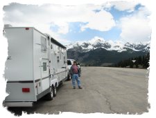 Another long and scenic climb up to the wonderfully named Lizard Head Pass. I was curious about this side of the loop drive, because I was scouting which route would be better to pull the camper in a few days. The back side of the loop only had one high pass to cross, and it avoided the Million Dollar Hwy section - a wonderful scenic drive, but a nightmare to pull a camper across! The 10,222 Lizard Head pass has proved to the be highest point the camper has gone so far. The truck pulled it fine, proving my brother-in-law right, who insisted at the beginning we were going to need a more hardy tow vehicle than the Ford Expedition we started with. Fortunately we listened to him and our GMC Diesel Sierra 2500 truck handled both the climb and the drive down without a serious effort.
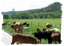 The drive back down was long and relatively uneventful. Following the Dolores River, we gradually descended back into red rock country. We saw a large herd of elk on the way down, and a few days later, pulling the camper, we were stopped by a herd of cattle munching on the roadside grass.
If you hung with us this far - it's one of the best drives we've ever taken, although long. You could easily split the route up into multiple days, and we wouldn't have minded staying in Silverton, Ouray or Ridgeway overnight - Telluride simply was too expensive to consider, although scenic. There are no KOA campgrounds in Telluride!!!
| Previous - Happy Birthday Miles | | Home | Index | | Durango & Silverton RR - Next |


<< Home