
AuSable Chasm
Wednesday, Sept 13, 2006 $16 a head seemed a little much to take a hike along a gorge, but being as we had already driven close to an hour to reach AuSable Chasm, we went ahead and paid up. The Chasm is billed as the ‘Oldest Natural Tourist Attraction’ in the US, a tribute to owners who were the first to figure out how to charge people (and keep charging for the next 130 years!) to look at a small gorge.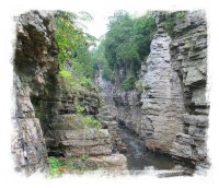
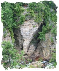
The money notwithstanding, AuSable Chasm is a beautiful little gorge in an improbable location – it’s only a couple of miles for the shores of Lake Champlain. Although Champlain is lined with mtns on both the New York (Adirondack and Taconic) and Vermont (Green Mtns) sides, the mountains are usually 10-15 miles off the lake. However, in one spot, the Adirondacks come down to lakes edge, and it is in this area that the chasm exists.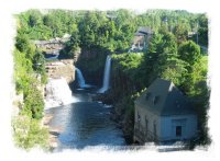
The geology is becoming familiar- glacier carved valleys leave a higher region of harder rock, with a soft rock under layer. For the past 10,000 years, the AuSable River (just like Niagara) has carved a 2 mile steep, narrow gorge, ending in a series of waterfalls. In fact, there was one small rapid that when viewed from above I felt mirrored Niagara Falls on a small scale, and it provided a good opportunity to discuss again with Vance how the river was carving the gorge thru erosion.
It was a wet day – fortunately, we are of the ‘have Gore-Tex will Travel’ crowd, and usually aren’t deterred by anything less than a torrential downpour. When viewing falls and rapids, rain is usually our friend as it raises the water level, and this was no exception.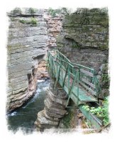
The trails are well maintained, and after a short walk along the rim, it descends down the chasm walls. A huge flood in 1996 destroyed much of the walkways lower in the gorge, and the trail has been raised somewhat since then to help prevent a similar fate in the future. Quite a bit of the old trail bridges and pathways still exist, and we met one woman on the trail who told us how she remembered walking the old (and precarious looking) pathways as a child on school trips.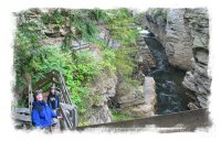
We enjoyed the walk and the views were dramatic. There is a short raft ride available in the lower portion of the gorge, which we passed up (we live very close to the Nantahala River, which is a popular whitewater rafting destination), but it was fun watching the rafts being lowered via cable from the rim of the chasm. The chasm at some points narrows down to about 60 feet side to side, and is about 150 feet deep.
By the time we finished up it had started a downpour, and we gratefully caught the bus ride back up to the visitors center. We followed up the tour with a drive further down the shore of Lake Champlain, viewing New York’s first fish ladder for salmon enroute. Later in the afternoon we caught a ferry across the lake to the Vermont side, and drove back to the campground.

Vance: Ausable Chasm had many different waterfalls. It was mostly formed by erosion. One section was closed because the stairway fell down from a flood. Then we saw a rock called Elephant Head because it looked like an elephant’s head. Next we saw a trail that led us into the gorge.
Later we came to a bridge that was damaged by the flood. While we were on the trail we saw many pieces of bridge steel in the water. Then we saw a crack you used to be able to walk in because it was decked. Next we saw some people do a short raft trip down the gorge. Finally we caught the bus and had a snack at the Visitors Center.
FLOODS, TOO MANY FLOODS!


<< Home