
Acadia National Park
Thursday, October 12, 2006
We spent a tantalizing, but curiously incomplete stay at Acadia National Park. Despite our many trips into the park, I came away with an impression of only barely experiencing what the park has to offer. While we enjoyed our stay here , and to date this is the longest we’ve stayed in one location - I wish it could have been even longer.
I can’t quite put my finger on it, but I don’t feel we were ever quite able to wrap our arms around Acadia. It’s not for lack of trying, as we participated in several Ranger programs. We drove the Park Loop Road, Vance completed his Jr. Ranger activities, and we walked down several of the unique carriage roads. We visited museums in the park, climbed down the bluffs to view a sea cave and tidepools, and Vance and I hiked up one of the mountains, finishing up right at sunset. But despite all of this, it feels like we just nibbled at the edges of the park.
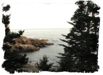
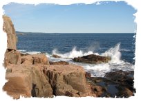 Acadia is undeniably beautiful, with its wild, rugged coastline; pink granite mountains that plunge right down to the sea; glacier carved ponds, and the dramatic fall foliage. While you can see a lot from your car, a few short walks can really add to your experience. Ultimately, though, I think you just have to sit awhile and soak it in.
Acadia offers so many different views and impressions (coastline, valleys, ponds, mountaintops, inlets….), that it would take some time to really do it justice. Despite the fact we were on the island for 10 days, there was enough competition for our attention elsewhere (Bar Harbor, Whale watching, sailing, museums, etc…) that it’s easy to get distracted from the park. Throw in all of us being sick to one degree or another and the opportunity became limited to just sit on the shoreline and marvel at the waves, or walk alongside the ponds ablaze with fall color.
There are really 5 levels of transportation corridors in Acadia, each carefully situated to avoid impacting the others. The first is the normal road system on the island. Several state highways and county roads intersect the park, but much like roads around the Blue Ridge Parkway, they are carefully hidden from sight from inside the Park itself. When in the park, you have to look carefully to detect the existence of these roads, even though in many cases they run very close to Park roads.
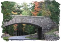
The next layer is the Park Loop Road, a 27 mile long road that circles the main area of the park. The road was designed by Frederick Law Olmsted. Olmsted is best known for his design of New York’s Central Park, but we are also familiar with his work as the landscape designer for the Biltmore House in Asheville, and a set of ‘string of pearl’ parks in Atlanta. The road covers several geologically diverse areas of the park, including the rugged coastline that Acadia is probably best known for. The two lane road is one way for about ½ it’s distance, and the right lane is designated as a parking lane, allowing one to stop and gawk anywhere the view warrants, which is often. It’s a beautiful drive, although it’s our understanding that the traffic during the summer months can be bumper to bumper, something that’s easy to believe given our experience with the Smokies.
The most interesting of the transportation corridors are the carriage roads. The park owes much of its existence to donations by John D. Rockefeller, Jr. Rockefeller’s father, John Sr, loved to design and build scenic roads on the various Rockefeller estates, and his son inherited his fondness for this activity. There was some controversy over the construction of the Loop Road, as it was felt that the noisy automobiles of the day would distract from the natural experience the park offered. In response, Rockefeller supervised the construction of a series of carriage roads (basically, one lane gravel roads), whose usage was (and still is) restricted to walking, biking or horse carriages.
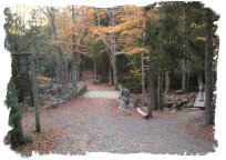
These lovingly maintained trails offer easy access into the interior of the park, often passing close to the numerous ponds or tidal inlets in Acadia. The park offers horse drawn carriage rides, unfortunately, due to an ill timed set of colds, none of us felt up to it in the few days we were at Acadia prior to the end of the season for the stable.
 The foot trails offer perhaps the most intimate view of the park. Like most National Parks, you don’t have to get far off the road to lose the crowds. Vance and I opted for a 4 mile hike up and back the North Ridge Trail, climbing to the top of Mt. Cadillac, the highest mountain on the island. Vance for the most part did well on the hike, which was quite steep and rocky in places. He did get rather discouraged on several occasions when what we both thought was the top proved to be just another crest, and the next ‘top’ looming several hundred feet above us. But with some prodding he persevered, and we both enjoyed a great 360 degree view of Mt. Desert Island and the Atlantic from the top.
Finally, much of Acadia lies on surrounding islands, which can only be reached by boat. There are several ferries that will transport you to the various islands – Little Cranberry, Long Porcupine, Isle du Haut, to name a few. On Little Cranberry there is a small history museum and a lighthouse. Acadia only occupies about half of the land on Mt. Desert Island. The island doesn’t seem that large from a map, but we managed to drive over 500 miles without leaving the island, and there are several sections we never visited.
 My favorite moments at Acadia came on our last day there. It was an overcast day – a squall had blown through earlier that morning, shaking the camper with its fierce gusts of wind and rain. Using her best pirate accent, Denise roused Vance from sleep telling him: "ole Thunder Hole - she be blowin today, Matey!" We decided to drive the Park Loop Road one last time, mainly to complete the last few miles that for one reason or another we hadn’t covered yet.
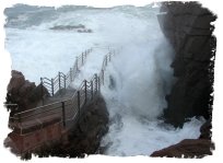
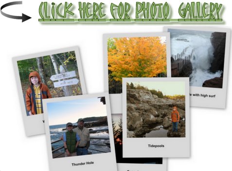
A few days earlier, when stopping at Thunder Hole (a spot where the crash of the waves sometimes produces a distinctive thundering sound), there wasn't any thunder, just some gurgling and hiccuping. It was quite pretty, just not much in the way of crashing waves.
However, with the storm, the waves were now far higher along the coastline. We again stopped at Thunder Hole, and this time the view was simply spectacular, with the power of the breaking waves on the jagged rocks on full display. Vance and several other children present would excitedly predict the size of the next crash based on the wave coming in, and after a few guesses got pretty good at it. The spot where we had paused for a picture at the end of the walkway a few days before was now completely covered with the breaking surf.
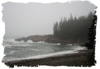
 We later made a brief stop a little further down the road at what I call Memorial Cove. Whatever its real name is, it is a small, private cove opening up to the ocean. The beach is composed of thousands of round rocks, 2-3 inches in diameter, and the sides of the coves were rocky headlands. It’s a lovely, peaceful spot. I liked it immensely.
Denise and I had been discussing the possibility of scattering more of my father’s ashes somewhere in Maine – according to Daddy, the only states of the lower 48 he had never visited were Maine and Washington State. I know exactly the spot in Washington, but up until now, I simply hadn’t found a location that felt comfortable in Maine. We had considered the sailboat ride we had taken a few days ago, as Daddy had built our family a sailboat (the Door), and we spent many happy summers up at Lake Hartwell camping and sailing. However, we were sharing the sailboat cruise with a high strung and awkwardly mannered woman from Washington, D.C., and it simply didn’t feel right.
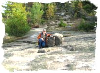
When we first found the cove, Vance, seemingly understanding what I had in mind before I did, climbed up to a rocky promontory with several rocks from the beach, which he stacked and called ‘a memorial’. Either by accident or design, the spot he picked was perfect, so I told him my intentions. We then had another small ceremony and scattered a little more of Daddy over the windswept rocks. Visiting again a few days later, I was rewarded with the view of towering waves crashing against the ‘memorial point’, with the spray bursting high above the rocks. It was a breathtaking view, and one I know Daddy would have loved. I felt good about the choice. I promised Vance I would bring him back when he was older so he could remember the location.
This is a great time of the year to visit Acadia. Although Bar Harbor, just outside of the park, can get crowded due to the influx of people off the cruise ships, very few of them venture into the park due to their limited time. The traffic is minimal, and the trails are nearly people free. The leaves were gorgeous, and all you need is just a little bad weather offshore to produce mind boggling surf in the coastal areas of the park. Columbus Day, a holiday that pretty well doesn’t exist in the south, is a big date here, as it marks the end of the season for the majority of establishments on the island, so if considering a fall visit, plan accordingly.
Just be sure to leave enough time to just sit for a day or two to soak it all in.

Vance: Acadia National Park is very cool. It is inhabited by Peregrine Falcons. The park is mostly bordered by the Atlantic Ocean. We spent some of our camping days driving around Acadia. One trail was called the Precipice Trail. They close it in the spring so the Peregrines can have a place to nest. The trail is closed right now because they had an earthquake a few days before we arrived.
There was one spot called Thunder Hole. They call it that because when the tide is strong it sounds like it is thundering. Another spot was a rocky spot but it could give you a good workout. Dad and I went inside the cave then we saw a tide pool that was full of starfish.
A PARK OF BEAUTY AND HISTORY!
P.S The Park is on an island called Mt. Desert Island.
P.P.S Some people pronounce Mt. Desert like Mt. Dessert.


<< Home